The navigation markers.

The three markers with the faint outline of a deep sea vessel above West Mouse.
Carmel Head/Trwyn y Gader lies at the extreme north west tip of Wales on the Isle of Anglesey. Offshore are The Skerries/Ynysoedd y Moelrhoniaid guarded by a lighthouse, while to the east of them is Maen y Bugael/West Mouse. This is one of three small islands - East/Ynys Amlwch, Middle/Ynys Badrig and West/Maen y Bugael off the north coast.
On the mainland opposite West Mouse are two large triangular stone towers erected by the Mersey Docks and Harbour Board in the 1860's as an aid to navigation on this dangerous coastline. The two towers line up with a third marker on West Mouse.
These navigation marks are the Coal Rock Beacons, known colloquially as the White Ladies. The sight-line through them and the West Mouse Beacon aligns with the dangerous Coal Rock, which is awash at low water spring tides. This lies a little further offshore beyond the Mouse. Coal Rock is the centremost of a group of three - Ethel Rock to the west and Archdeacon Rock to the east. Coal Rock is a hazard to navigation as it lies sufficiently far offshore (one and a half miles ) to constitute a danger to vessels making a passage to or from the Point Lynas/Amlwch direction and passing outside ( to the north of ) the Skerries. This was particularly so in the days of sail when coastal traffic was intense and the need to tack against adverse winds made diversion from a direct course necessary.
In addition to
the beacons
Trinity House marked each of the three rocks with its own
buoy (black
conical ) and at night the Skerries Lighthouse shone a red
sector over the area
warning of the danger. The beacons were painted in
1955 when a party
was put ashore by the Trinity House Vessel "Argus", which
used to be
based in Holyhead. Many thanks to Norman Sheldrick
for much of the
above information.
In 1972 the
beacons were painted again by Peter Hughes-Davies and Alan
Palmer. Peter writes: 'I understood the land
owner, John Roberts, had an arrangement with Trinity House
to maintain them and asked us to paint them as part payment
for rent in addition to being the "night shepherd" during
lambing season'.
Any practical use of the towers would have been very many years ago but they remain in excellent condition. Today's commercial shipping keeps well clear of this coastline, with its fast currents and notorious rocks although yachts and fishing boats are a common sight. Further details on the history of this site are most welcome, please contact me here.
Carmel Head is a beautiful area of rocky coastline and is accessed by the Anglesey Coastal Path and from other footpaths in the area. As there is little shelter and no habitation on this coastline the weather forecast should be checked before starting out Stout footwear and appropriate clothing are also recommended.
Image
produced
from the Ordnance Survey Get-a-map service. Image
reproduced with kind
permission of
Ordnance Survey and Ordnance Survey of Northern Ireland.

Carmel Head with The Skerries and their lighthouse visible offshore.
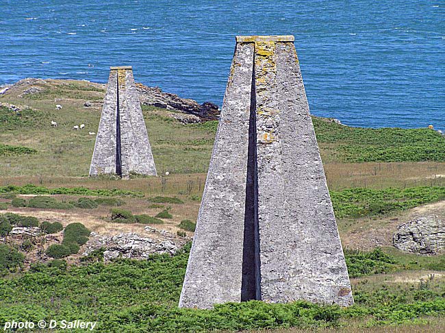
A closer view of the two mainland markers.

The marker on West Mouse looking like a giant chess pawn in this close up view. The current can be seen breaking over Coal Rock in the background.

Wylfa nuclear power station is seen in the distance.
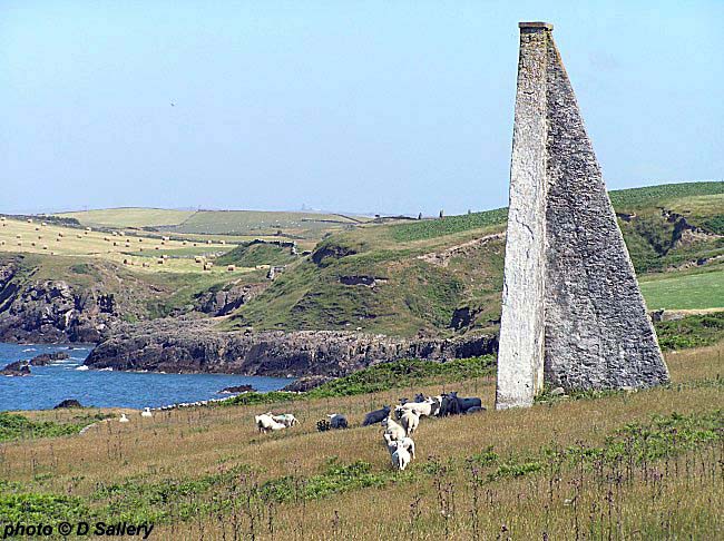
These sheep give an idea of the size of the markers which is about 45 feet.

Carmel Head was also the site of a small copper works, the chimney of which is shown here.
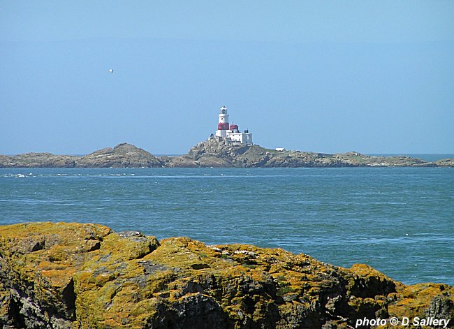
A close up view of the Skerries lighthouse, now unmanned and automatic.

Some of the stunning coastal scenery around Carmel Head.
Return to the index page
Please visit my other websites at penmorfa.com and my Flickr photo site.